Railroads were the impetus behind changing this state of affairs to something a little more reasonable. And that makes a lot of sense. Can you imagine the hell this created with time schedules?
It was 1883 when the railroads got together and carved up the country. There were a number of changes after that over the years, but this is how it all ended up:

So, I can definitely see some logic to this scheme here. But what I want to know is, what the heck’s going on with Idaho, or Oregon, or Indiana, or Michigan, or all those states along the 104° line? I was assuming the zones would follow state borders where they can (but maybe break up long states that seemed to straddle two zones, like Kentucky and Tennessee). What the heck’s going on here?
I mean, take a look at Australia, another big country with multiple time zones. They make it look pretty simple:

Notice how the time zones go right along the borders of the different territories. There are no little towns in Queensland that are in the time zone of the Northern Territory, no little enclaves in Western Australia that don’t follow Western Australia time, no yellow territories that aren’t in the same time zone as all the other yellow territories. The borders themselves go pretty much up and down. Why can’t we be more like the Australians?
So, let’s take a look at the different states, and see how illogical things actually are. I’ll go from least egregious to most egregious.
8. Texas
Texas is a big state. So. it’s not too surprising that it takes in two time zones. It’s also not too surprising how they’ve actually gone about dividing those two time zones up …
In the far western tip of Texas is the major city of El Paso. Now, it so happens to be to the west of MT cities like Denver, and Santa Fe, and Cheyenne. Actually, would you believe El Paso is actually closer to San Diego than it is to Houston? Yup, we’ve definitely got an MT city here.
Now, there also so happens to be very little happening east of El Paso. There is, however, quite a lot going on just southwest of the city, across the border in Mexico’s Ciudad Juarez, which just so happens to be on Mountain Time as well.
So, not too bad an idea …

I’m not totally sure why Hudspeth decided to go along for the ride (or that little bit of Culbertson), but there you have it.
Thanks to the Houston Chronicle for some of this info.
VERDICT: Sure, why not?
7. Kentucky / Tennessee (tie)
You’re going to have to divide these two at some point. There really aren’t any other states that are long and skinny like these guys … and run right across two time zones. So, the only question is, where are you going to draw that line?
Kentucky actually does a pretty good job. The line they’ve drawn separates two distinctive regions – the Cumberland Plateau and the bluegrass region – from the rest of the state:


Note that the time zone border gives Louisville a little bit more of a buffer, as well as nipping off that little wedge of Mississippi Plateau. Nice work!
As for Tennessee, that’s not too bad either. It looks like they’ve basically taken the mountains, the Valley, and the Cumberland Plateau and given them to ET, with the rest of the state given to CT.


I might move those 5 border counties – Fentress, Cumberland, Bledsoe, Sequatchie, and Marion – over to ET, but otherwise it’s not bad.
VERDICT: I’m not sure KY needs to change anything. TN should probably move those 5 counties over though.
6. Indiana
Indiana reminds me a little of Texas. Both have some big cities in the corners of their states. In Texas, it’s El Paso. In Indiana, it’s Evansville in the southwest, and Gary in the northwest.

Evansville makes some sense. There is that little wedge that the Wabash River creates as it meanders over to the southwest. The line they’ve carved out also matches up pretty well with the line that goes through Kentucky. On the other hand, though, there is no big neighbor to the west here, like Ciudad Juarez … or Chicago.
Yup, though the border in the northwest is all right angles, Chicago makes a lot bigger splash than Ciudad Juarez. Heck, Gary’s really just a suburb of Chi-town, right? Makes a fair amount of sense, at least to me.
VERDICT: I can live with it. You know, what would really be cool, though? Just move the whole darn state over to CT.
5. Idaho
The Panhandle of Idaho (called North Idaho by the natives) is only tenuously associated with the rest of the state. Number one, it’s just too far away. Number two, there’s all those mountains separating it from the main part of the state, which basically makes up the Snake River Valley. Number three, there’s Spokane, a city of half a million, right across the border in Washington.
So, this one makes a lot of sense. Where it all falls apart, though, is the line they actually draw across the state. Now, their hearts do seem to be in the right place – they basically simply follow the Salmon River across the state.

In fact, they actually follow it rather religiously – which means that the border follows a really crazy loop in the western part of the state:
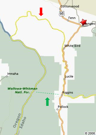
Now, of course, nobody actually lives in that loop, but why not just cut right across? That’s what they do in the eastern part of the state. Could work here too, right?
You know what would be even more straightforward though? Why not just put the border along the county line?

That’s Idaho County that getting split in two, by the way (one of only a handful of counties where that happens). You know, you could have the time zone include the county, or exclude it. Whether you use the county’s northern border or southern border, though, the integrity of the county line would remain intact, and the line would at least seem to be a little more practical.
VERDICT: Makes sense, but I really don’t like it. Make me happy and use that county line, though okay?
4. Oregon
Alright, this is just plain goofy. You’ve got one county, Malheur, that just doesn’t want to play along with the rest of the state. Just to make things even more interesting, though, the very southern part of the county doesn’t seem want to play along with the rest of the county!

So, what’s this all about? The only possible reason I can think of is proximity to that major metropolitan region of Boise, ID. Turns out this is actually the case, especially as the majority of Malheur’s population is in the northern part of the county – right across from Boise. Also, there’s not a whole lot to the west, in Oregon, until you get Bend, and then Eugene, and then Portland.
VERDICT: I kind of get it, but this is just ridiculous. Make all of Oregon PT. In fact, let’s just tidy things up and have a nice, clean, logical line like this:
3. Kansas / N. Dakota / S. Dakota / Nebraska
This one could have been so perfect. There’s a nice vertical line, around 104°, that divides up ND, SD, NE, OK, and TX on one side, and MT, WY, CO and NM on the other. It also looks like a pretty darn clear place to throw that time zone border as well.
So, what's all that crazy stuff going on in Montana, and, South Dakota, and Nebraska, and Kansas? Why does a little piece of each of those states have to move over to Mountain Time? Wouldn’t it have been just so much easier to follow each state’s borders? If nothing else, it would have dealt a serious blow to the irony of having those four extremely flat states having anything to do with the Mountain Time Zone.
Okay, let’s look at these losers one by one …
North Dakota’s just doesn’t seem make any sense. South Dakota’s, on the other hand, does at least seem to split the state in two. Nebraska? Haven’t a clue. Kansas? You got me.
I do know, though, that Kansas is – without a doubt – the most egregious of the four:

What were those four counties thinking? It’s not like there’s anything over the border. Or any difference between those four and any other county within 100 miles.
VERDICT: This is just lame, guys. Color within the lines, would ya?
2. Michigan
Those poor Yoopers. They must feel less a part of their state than the North Idahoans are of theirs.
Now, I was figuring that these guys are either gonna go with Michigan’s ET, or with Wisconsin’s CT. They're kind of right on the border between the two. But noooo. We’ve got to try and do both now, don’t we?

Yup, all the counties that border Wisconsin are CT, while all the rest are ET. Why? I have no idea. It’s not like there any big cities over that border.
So, what we’ve got here is an area with two time zones but only one area code. That just doesn’t seem right.
VERDICT: Let the UP go CT.
1. Florida
On the surface of it, this one makes a lot of sense. The Panhandle makes Florida – like Kentucky and Tennessee – one of those longer states that straddles ET and CT. Further, the line between the two is a fairly natural one – the Apalachicola River. Additionally, that river also functions as county line for no less than 6 counties, from the Alabama state line to the Gulf of Mexico. Finally, that line is almost directly below the Alabama – Georgia border, an almost vertical line that separates ET and CT all the way up to Tennessee.

All well and good. But here’s where it all falls apart:

Let me explain … The river actually hits the gulf at the town of Apalachicola. For some reason, though, the time zone (that little dotted yellow line) zips up a little tributary to the northwest, goes through Lake Wicomico, travels along a canal, hooks up with another little river, hits State Road 386, then follows 386 south to the Gulf. WTF???
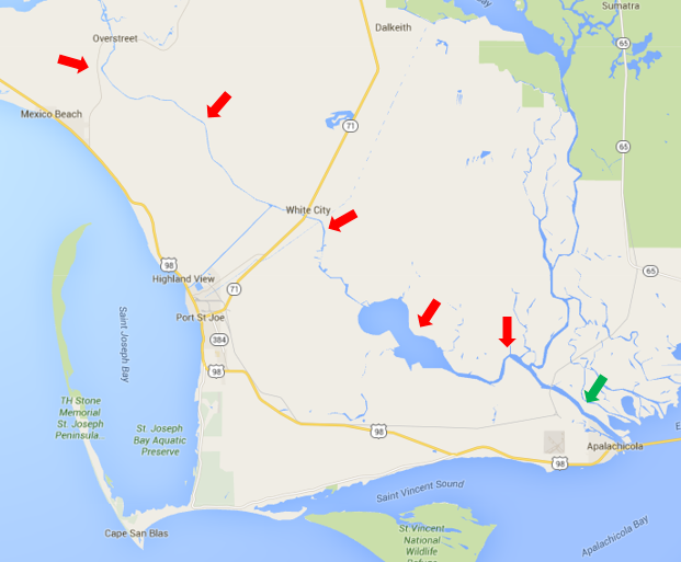
How did this all come about? Well, would you believe it was some rich guy who wanted his offices, in Jacksonville, and his paper mill, in Port St. Joe, in the same time zone? Well, that guy was one Ed Ball, one of the most powerful men in Florida, and that company was the St. Joe Paper Company, which is still around today.
And, yes, I’m afraid that one is too good to be true. Sounds like it might have actually been the Apalachicola Northern Railroad instead. Turns out that line ran right along the ET – CT border, with just a teeny, tiny little jog at the end over to St. Joe’s.

Thanks for that great info, Orlando Sentinel.
VERDICT: You really messed it up, guys. If it wasn’t for the St. Joe’s thing, you guys could been #8. You definitely gotta move that thing back.
More geography stuff:
- Relative sizes of states and countries
- The meanings of country names
- The meanings of state names
- Crazy demonyms (what you call people from a certain place)
- How many Springfields are there in the US?
- The most and least accessible state capitals
Great research, Cliff. Very enjoyable.
ReplyDeleteThe Evansville one definitely makes sense because the Evasnville metro area includes some places in Illinois and Kentucky. Illinois is entirely central, while that part of Kentucky is central time.
ReplyDeleteFor Michigan, if more of the UP were to move to Central Time, I would leave Chippewa, Luce, and Mackinac counties in Eastern Time (there's a very sharp divide between the eastern UP and the western UP around M-77)
ReplyDelete